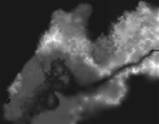
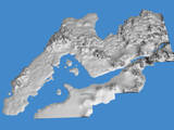
 Concept Art - Original Project Height Map Concept Art - Original Project Height Map |
      |
This is the original height map created by Gyssar for the mod, which we
have since modified and developed with LOD as an ESM.
Although Gyssar did a fantastic job with the landscaping and overall
terrain design, we did discover some fairly major flaws. As a result we
have decided to generate a new version. At present, we can offer the
following list of items which we discovered were missing or incorrect:
- The Ilessan Hills (about 1/3 of the way up from the lower left
corner) are in the wrong place. They should be near the central and
eastern portions of the peninsula from where they currently appear.
- The peninsula itself needs to be wider to allow more room for settlements and locations.
- Betony Isle needs to be added off the southern coast of the peninsula.
- The Kurallian Mountains around Shornhelm are too shallow, forming a large number of plateaus.
- The Bjoulsae River needs some serious work - the river forks to the
east and there some inconsistencies and shallow spots along its length.
- Balfiera Ilse and its island chain need to be redone for accuracy.
- Tamrilyne Point on the coast of Menevia needs to be added.
- The eastern edge of the map near Farrun and Jehanna does not cover
enough area. At present, Jehanna itself must be located too far west to
be accurate.
- In addition to the point above, not enough room was allowed for LOD cells on the edge of the map bordering Skyrim.
- Finally, the map was generated without provision for riverbeds,
roads, too few lakes and no flatter areas added for cities, towns and
settlements.
Gyssar and I are responsible for creating that particular list of items
that need adjustment or correcting. We would like to invite everyone
else to see if they can find anything to add to the list for
consideration in the new height map. Since it is currently under
development, this allows some really valuable input which Gyssar can
refer to as he works on it. Braggi has attached these images (downsized versions):
 
This post has been edited 7 time(s), it was last edited by Braggi: 2008.09.28 21:39.
|


