 Skyrim Heightmap in 3d Skyrim Heightmap in 3d |
Vality7
Guardian


Registration Date: 13.08.2006
Posts: 53
Location: Nouvelle-Zelande
 |
|
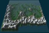
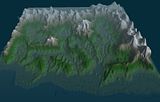
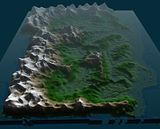
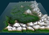
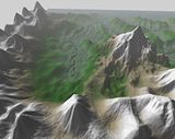
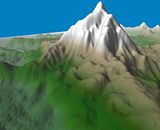
I made a few 3d pics of your heightmap (using your latest .esm) which
i'll show here if you don't mind. This just gives a good overall look
at your province. The colours are of course not meant to mean anything,
I just made them up based on height, I imagine theres a bit more snow
that this.
The heightmap is looking ok, my main concern is that it doesnt really match the outline shape that it looks like in your maps.
Theres a few bits i've noticed that look a little unnatural, I mean, in
reality, everything has to flow downwards, unless its formed some sort
of high mountain lake, which isn't usually common, it usually breaks
before long. There are of course glaciers, but the things I see don't
look typical of glacial formation.
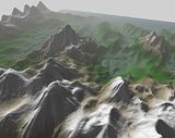
Like look in the Skyrim 5 picture for example, on the right side of the
image, there are many cases of unrealistic flow. This kind of thing
wouldn't matter to most people, but as a heightmapper myself, I tend to
notice such problems. So it doesnt really matter, just pointing it out
that there should be a little more flow, like you cant expect
geocontrol to do all the work for you or some kind of automatic eroding
tool.
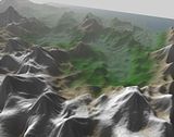
| Looking North |
Looking South |
Looking West |
Looking East |
 |
 |
 |
 |
 |
 |
 |
 |
__________________
- My Mod Website
This post has been edited 2 time(s), it was last edited by Vality7: 24.02.2007 11:35.
|
|
 24.02.2007 11:31
 |


|
|
|
|
It's still in progress, only the Rift area is moddible at the moment, and it is acurte to my eyes.
TOYB
|
|
|
24.02.2007 19:27 |
|
|
Alasdair
Jarl of Skyrim


Registration Date: 29.08.2006
Posts: 1,169
Location: Somerset, England
|
|
| RE: Skyrim Heightmap in 3d |
     |
| quote: |
Originally posted by Vality7
The heightmap is looking ok, my main concern is that it doesnt really match the outline shape that it looks like in your maps. |
I took some artistic licence with falkreath, but other than that it
should be pretty accurate (especially the coastlines). The thing that
bothers me most is the relatively small size of the velothi mountains,
but I couldn't build up any more mountains because of the 6 by 6 quad
limit that the game has. (the heightmap is sort of skewed to the east
due to the location of the original quad that the Grey Wizard did) it's
not that noticeable in game however.
| quote: |
Originally posted by Vality7
Like look in the Skyrim 5 picture for example, on the right side of the
image, there are many cases of unrealistic flow. This kind of thing
wouldn't matter to most people, but as a heightmapper myself, I tend to
notice such problems. So it doesnt really matter, just pointing it out
that there should be a little more flow, like you cant expect
geocontrol to do all the work for you or some kind of automatic eroding
tool. |
I actually made the rivers before the mountains exactly as they were
shown on the map, as they gave me an idea of where everything was. Plus
I used the CS heightmap editor (yes I'm a total masochist  ) so there were no erosion related shenanigans beyond what the CS editor allows.
|
|
|
24.02.2007 22:28 |
|
|
|
|
| RE: Skyrim Heightmap in 3d |
|
| quote: |
Originally posted by Alasdair
| quote: |
Originally posted by Vality7
The heightmap is looking ok, my main concern is that it doesnt really match the outline shape that it looks like in your maps. |
I took some artistic licence with falkreath, but other than that it
should be pretty accurate (especially the coastlines). The thing that
bothers me most is the relatively small size of the velothi mountains,
but I couldn't build up any more mountains because of the 6 by 6 quad
limit that the game has. (the heightmap is sort of skewed to the east
due to the location of the original quad that the Grey Wizard did) it's
not that noticeable in game however.
| quote: |
Originally posted by Vality7
Like look in the Skyrim 5 picture for example, on the right side of the
image, there are many cases of unrealistic flow. This kind of thing
wouldn't matter to most people, but as a heightmapper myself, I tend to
notice such problems. So it doesnt really matter, just pointing it out
that there should be a little more flow, like you cant expect
geocontrol to do all the work for you or some kind of automatic eroding
tool. |
I actually made the rivers before the mountains exactly as they were
shown on the map, as they gave me an idea of where everything was. Plus
I used the CS heightmap editor (yes I'm a total masochist
) so there were no erosion related shenanigans beyond what the CS editor allows. |
To get the extra area for beyond the borders, we decided upon LOD hacking (A very long time ago now).
|
|
|
24.02.2007 22:44 |
|
|
Vality7
Guardian
Registration Date: 13.08.2006
Posts: 53
Location: Nouvelle-Zelande
|
|
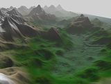
I'm not talking about the rivers, i'm talking about the flow down the mountains and slopes. I'll show you what I mean.
This picture shows the mountain as it is now:
This picture shows how with the current way it looks, with the flow of
mts in pink, and the areas where water is building up. Realistically,
the flow and erosion would create many lakes everywhere, but usually
these lakes would overflow quite fast and continue to form ridges, or
if frozen they'll form glaciers and slowly creep down forming huge
valleys.
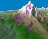
So the best way to do it is by creating a realistic looking flow down
every slope there is, unless you intend there to be a lake at a certain
point, but as it is now, there'd be far too many lakes. Heres a quick
edit of how that should flow more realistically:
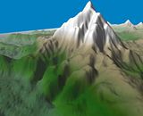
So, most people don't care about this kind of thing, i'm just pointing
it out as a heightmapper should know of this. And yeh, for an extra
touch of realisim, I would reccomend exporting the RAW, running it
through Geocontrol with the proper erosion settings, and reimporting it
back in. If you do it right, theres no loss in quality, and you can do
it for free if you download the trial version.
__________________
- My Mod Website
This post has been edited 1 time(s), it was last edited by Vality7: 25.02.2007 06:58.
|
|
|
25.02.2007 06:55 |
|
|
Alasdair
Jarl of Skyrim
Registration Date: 29.08.2006
Posts: 1,169
Location: Somerset, England
|
|
I'll see about fixing up the slopes, I can't say I was really thinking
about how water would flow down them when I made them. |
|
|
25.02.2007 22:01 |
|
|
SACarrow
The Voice Guy


Registration Date: 26.04.2006
Posts: 1,793
Location: Tampa, Florida, USA
|
|
It might be cool though to have one or two mountain lakes high on The
Throat of the World (which is where I think Vality7's example is).
Later,
Steve
|
|
|
25.02.2007 23:20 |


|
|
Richard
Chieftain of Skyrim

Registration Date: 23.08.2006
Posts: 747
Location: Invercargill, New Zealand
|
|
Wait wait...is this bad news??? I won't have to put Vernim Wood on another heightmap will I??
|
|
|
26.02.2007 00:17 |
|
|
Psychotic
Jarl of Skyrim


Registration Date: 30.07.2006
Posts: 3,420
Location: Sheogorath's Realm
|
|
| quote: |
Originally posted by Richard
Wait wait...is this bad news??? I won't have to put Vernim Wood on another heightmap will I?? |
I don't think those cells will be modified.
|
|
|
26.02.2007 01:35 |

|
|
Rincewind
Warder

Registration Date: 28.09.2005
Posts: 42
|
|
| quote: |
Originally posted by Vality7
So the best way to do it is by creating a realistic looking flow down
every slope there is, unless you intend there to be a lake at a certain
point, but as it is now, there'd be far too many lakes. Heres a quick
edit of how that should flow more realistically:
[ IMG]http://i73.photobucket.com/albums/i201/Vality7/skyrim/s2.jpg[/IMG ]
So, most people don't care about this kind of thing, i'm just pointing
it out as a heightmapper should know of this. And yeh, for an extra
touch of realisim, I would reccomend exporting the RAW, running it
through Geocontrol with the proper erosion settings, and reimporting it
back in. If you do it right, theres no loss in quality, and you can do
it for free if you download the trial version. |
Please, don't. This dosn't look natural in any way. Rivers don't start
that far up. Look on a map and you will see that this is all wrong. |
|
|
26.02.2007 01:59 |
|
|
Vality7
Guardian
Registration Date: 13.08.2006
Posts: 53
Location: Nouvelle-Zelande
|
|
| quote: |
| Originally posted by RincewindPlease,
don't. This dosn't look natural in any way. Rivers don't start that far
up. Look on a map and you will see that this is all wrong. |
Haha, they aren't rivers dummy.  I take it you've never been to the top of a hill/mountain.
And which map are you refering to? A map of anywhere on Earth? Go look
up detailed maps of like the Swiss Alps, or the Southern Alps of NZ,
you'll find that streams do start that far up, and is how gullies and
ridges are carved, its called water erosion.
Where do you think water/streas/rivers come from? Think about it, when
it rains, naturally it hits the heightest point first, being the top of
a mountain, it flows downward, slowly carving away at the rock over
time, creating the gullies and erosion you see all over the Earth.
And if you mean by my 3rd example of it not being realistic, well yeh,
thats cos I spent about 10 secs editing it just to show how flow should
work. It wasn't meant to be how it should look in final form, I just
done a quick edit for an example. If I had made the entire mountain
from scratch, you would be saying it is a lot more realistic than
present. Its hard to carve out a mountain more realistic when its not
totally realistic to begin with, without changing its entire shape.
So yeh, go do a little research, you might learn something. 
@Alasdair, yeh I know most people don't think about that sorta thing,
and most players wouldn't care. So its not really necessary that you
edit your map, its up to you. I'm just pointing it out for in future I
guess, and if you want a more realistic look. Its a simple concept of
how flow and erosion works, and once you know it and have it in mind
when making maps, you'll find that in the end, they'll look a lot more
realistic when complete. ")
__________________
- My Mod Website
This post has been edited 1 time(s), it was last edited by Vality7: 26.02.2007 05:25.
|
|
|
26.02.2007 03:29 |
|
|
Alasdair
Jarl of Skyrim
Registration Date: 29.08.2006
Posts: 1,169
Location: Somerset, England
|
|
| quote: |
Originally posted by Vality7
And if you mean by my 3rd example of it not being realistic, well yeh,
thats cos I spent about 10 secs editing it just to show how flow should
work. It wasn't meant to be how it should look in final form, I just
done a quick edit for an example. If I had made the entire mountain
from scratch, you would be saying it is a lot more realistic than
present. Its hard to carve out a mountain more realistic when its not
totally realistic to begin with, without changing its entire shape. |
When I made the mountain, I was more thinking about :
Will the player be able to climb to the top?
and
Will the player be able to walk around it?
I'll see if I can get some of the mountains to be more realistic, as
you're probably right, but whether the mountains are navigable by the
player is important as well. |
|
|
26.02.2007 17:05 |
|
|
ev1
First Knight

Registration Date: 14.07.2006
Posts: 138
|
|
Good stuff Vality7.
__________________
Now I cant forget
coz my momma killed me
|
|
|
26.02.2007 17:24 |
|
|
Siegfried
Archduke


Registration Date: 07.03.2006
Posts: 2,598
Location: With Your Mom...
|
|
If anything I would be inclined to say that the mountain needs to be made more navigable rather than have more flow added.
|
|
|
26.02.2007 17:47 |
|
|
Vality7
Guardian
Registration Date: 13.08.2006
Posts: 53
Location: Nouvelle-Zelande
|
|
| quote: |
Originally posted by Liquid Cheese
Meh, that loses a lot of the sense of adventure if you aren't hoping
between tiny rocks to try to scale a mountain. Oblivion felt like one
massive national park or whatever they are called. Neat little paths
showing you the right way to go. |
I totally agree with this. It makes more sense to make it like a real
terrain, then try build ontop of it from there, the same way we had to.
Of course nowdays we are able to change the terrain to suit our needs,
but in Skyrim with their techonology, that is not the case.
A more natural, rugged feel i'd prefer. Of course you wouldn't be able
to get everywhere, but having a road to the heighest peak is a little
unrealistic. Having to gain mountain climbing skills to get there would
be better I think.
__________________
- My Mod Website
|
|
|
27.02.2007 02:55 |
|
|
Psychotic
Jarl of Skyrim
Registration Date: 30.07.2006
Posts: 3,420
Location: Sheogorath's Realm
|
|
| quote: |
Originally posted by Vality7
but having a road to the heighest peak is a little unrealistic. |
Well actually there IS a road of sorts that goes pretty far up the
mountain... 7000 steps to be precise, more like a stairway (all of this
is official lore). 
The steps lead to High Hrothgar (which is I would say at 3/4 of the
overall height of the Throat of the World) and are there so pilgrims
can get to the place more easily.
|
|
|
27.02.2007 04:00 |
|
|
Rincewind
Warder
Registration Date: 28.09.2005
Posts: 42
|
|
| quote: |
Originally posted by Vality7
| quote: |
| Originally posted by RincewindPlease,
don't. This dosn't look natural in any way. Rivers don't start that far
up. Look on a map and you will see that this is all wrong. |
Haha, they aren't rivers dummy.
I take it you've never been to the top of a hill/mountain.
And which map are you refering to? A map of anywhere on Earth? Go look
up detailed maps of like the Swiss Alps, or the Southern Alps of NZ,
you'll find that streams do start that far up, and is how gullies and
ridges are carved, its called water erosion.
Where do you think water/streas/rivers come from? Think about it, when
it rains, naturally it hits the heightest point first, being the top of
a mountain, it flows downward, slowly carving away at the rock over
time, creating the gullies and erosion you see all over the Earth.
|
I understand that. But the higher ypu get the smaller get the streams.
And the peace you showed didn't look very small. Bigger streams start
further downwards. Aditional you should consider the fact that the top
of an high mountain is to could for flowing water and glaciers aren't
that straight. |
|
|
27.02.2007 05:08 |
|
|
Psychotic
Jarl of Skyrim
Registration Date: 30.07.2006
Posts: 3,420
Location: Sheogorath's Realm
|
|
I assure you that there won't be any rivers or streams that look unrealistic or out of place anywhere on the heightmap.
|
|
|
27.02.2007 15:40 |
|
|
|


 Skyrim Heightmap in 3d


")


